A GIS and Remote Sensing Based Multi-Criteria Decision Analysis (MCDA) Approach Introduction Agriculture is one of the most important sectors supporting human life, food security, and economic development. Identifying suitable agricultural land is essential for sustainable farming practices, efficient resource management, and increasing agricultural productivity. Traditional land suitability anal…
1. INTRODUCTION Land cover classification is one of the most important applications of remote sensing, as it helps in monitoring urban expansion, studying vegetation cover, identifying water bodies, and analyzing land use. Many traditional classification methods rely on classifying each pixel independently; however, this approach can produce noisy maps, especially when using Sentinel-2 imagery wi…
Introduction Selecting an appropriate location for healthcare infrastructure is an important task in urban and regional planning. Geographic Information Systems (GIS) provide powerful spatial analysis tools that help planners identify suitable locations based on multiple criteria. This project demonstrates a Hospital Suitability Analysis workflow developed using QGIS. The objective of the study i…
If you want to build a strong foundation in Geographic Information Systems (GIS), AGSRT offers a comprehensive training program designed to equip you with practical skills. This course is ideal for students and professionals from civil, geography, environmental, and computer science backgrounds. It also suits those working in engineering, planning, data roles, and organizations needing scalable g…
ABSTRACT This study presents a spatial proximity analysis of pharmacy and Medical stores in the Ebute Metta area of Lagos using PostgreSQL with PostGIS extension. The location of all pharmacy stores in the area were mapped out and their accessibility to residential neighborhoods was studied. Geospatial queries, buffer analysis, and proximity calculations were applied to this study, underserved zo…
ABSTRACT This project developed an Automated Urban Vegetation Monitoring System to assess green cover changes in Ezza North LGA, Ebonyi State, using multispectral raster data from 2023 and 2024. NDVI was calculated from NIR and Red bands with Rasterio, NumPy, and GeoPandas after clipping to the study area boundary. Results showed a slight decline in vegetation condition, with moderate vegetation …
Introduction The web is no longer limited to flat, static maps. With modern geospatial libraries like CesiumJS, developers can build immersive 3D worlds directly in the browser. From visualizing terrain and satellite imagery to displaying buildings, flight paths, and real-time geospatial data, CesiumJS makes it possible to create rich, interactive globe-based applications with ease. If you are wo…
About the Training Program The Geospatial Automation and Development Program focuses on one goal. Turn your domain knowledge into practical, data-driven GIS skills. This is not a basic GIS course. You work on tools, automation, and real workflows used in industry which will be an effective upgrade for your GIS career. What you will learn Core GIS tools Work on ArcGIS Pro and QGIS Build end-to-end…
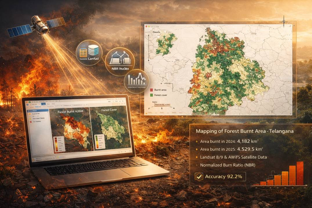
ABSTRACT The dynamic changes in forest fire regimes are affecting biodiversity and climate, therefore, mapping and monitoring burnt areas have become increasingly important, particularly during predominant fire seasons. Accurate mapping of burned areas is critical for proper resource allocation for combating fire hazards and prioritizing fire management strategies. The current study aimed to syst…
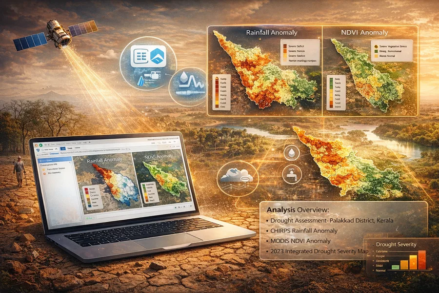
Abstract Drought is one of the most complex and spatially variable climatic hazards, affecting hydrological systems, agricultural productivity, and ecological stability across different climatic regions. The increasing variability of rainfall patterns and the growing dependence on climate-sensitive sectors have intensified the need for accurate and spatially explicit drought monitoring methods. R…
ABSTRACT Rapid urban expansion often leads to spatial imbalance in infrastructure distribution, particularly in essential services such as public water supply. This study evaluates ward-level water infrastructure adequacy within the Greater Hyderabad Municipal Corporation (GHMC) using a spatial database-driven approach. Ward boundaries and public water point datasets were integrated within a Post…
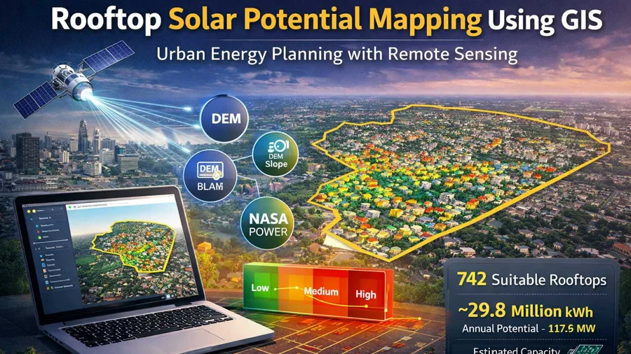
ABSTRACT Urban areas offer significant potential for rooftop solar photovoltaic (PV) deployment due to the availability of unused roof spaces and high solar radiation levels. This study aims to assess the rooftop solar energy potential of Chromepet, Chennai using GIS-based spatial analysis and open-source geospatial datasets. Building footprint data obtained from OpenStreetMap and elevation data …
How we built an interactive 3D building dashboard with floor-wise visualization, live temperature monitoring, heatmaps, and SMS alerts Introduction Modern buildings are becoming smarter, safer, and more data-driven. Traditional dashboards often show sensor readings as plain numbers or charts, but they fail to answer one important question: Where exactly is the problem happening inside the buildin…
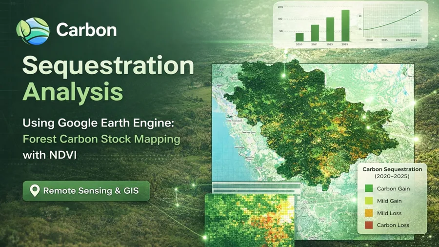
Introduction Carbon stock analysis helps estimate the amount of carbon stored in vegetation and soil and how it changes over time. Forest ecosystems play a major role in absorbing atmospheric carbon dioxide and storing it as biomass and soil organic carbon. Monitoring these carbon dynamics is essential for climate change studies, forest conservation strategies, and sustainable land management. In…
Using Closest Facility routes and Service Area coverage to evaluate hospital accessibility to accident locations. Introduction: Network Analysis and its real-world uses Network analysis in GIS models movement through a connected transportation network (roads), using real travel rules such as junction connectivity, one-way streets, turn restrictions, and time/distance costs. Unlike straight-line …
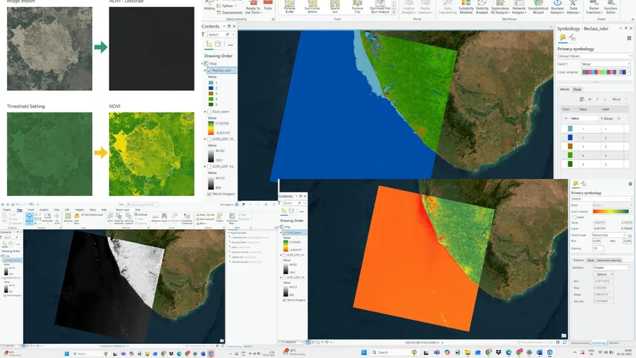
Introduction Normalized Difference Vegetation Index (NDVI) is used to quantify vegetation greenness and is useful in understanding vegetation density and assessing changes in plant health. It is a numerical indicator which uses the visible and near-infrared bands of the electromagnetic spectrum. Purpose Of NDVI Analysis 1) To estimate agricultural parameters such as crop yields, pasture performa…
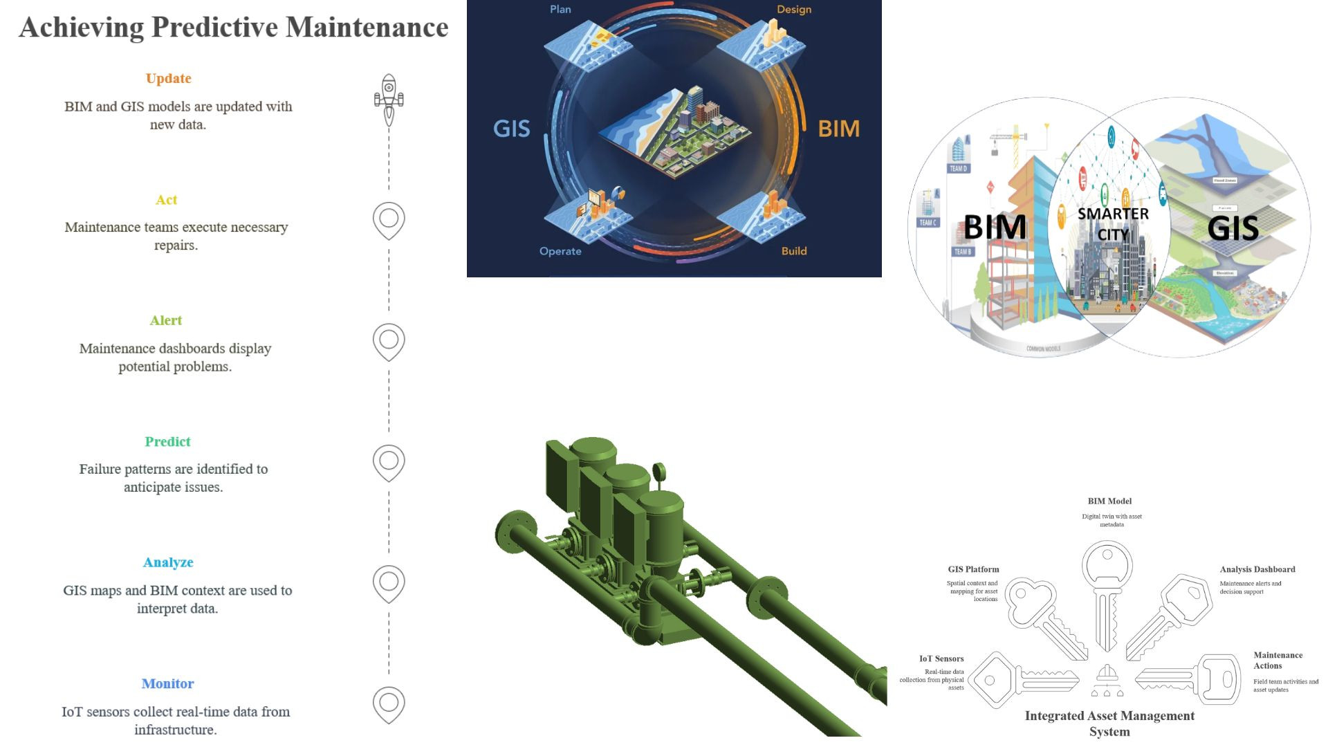
Introduction Infrastructure maintenance is no longer just about reacting to failures — it is about predicting them before they happen. As cities and organizations embrace digital transformation, the convergence of Building Information Modeling (BIM), Internet of Things (IoT), and Geographic Information Systems (GIS) is redefining how we monitor, manage, and maintain critical assets. This blog exp…
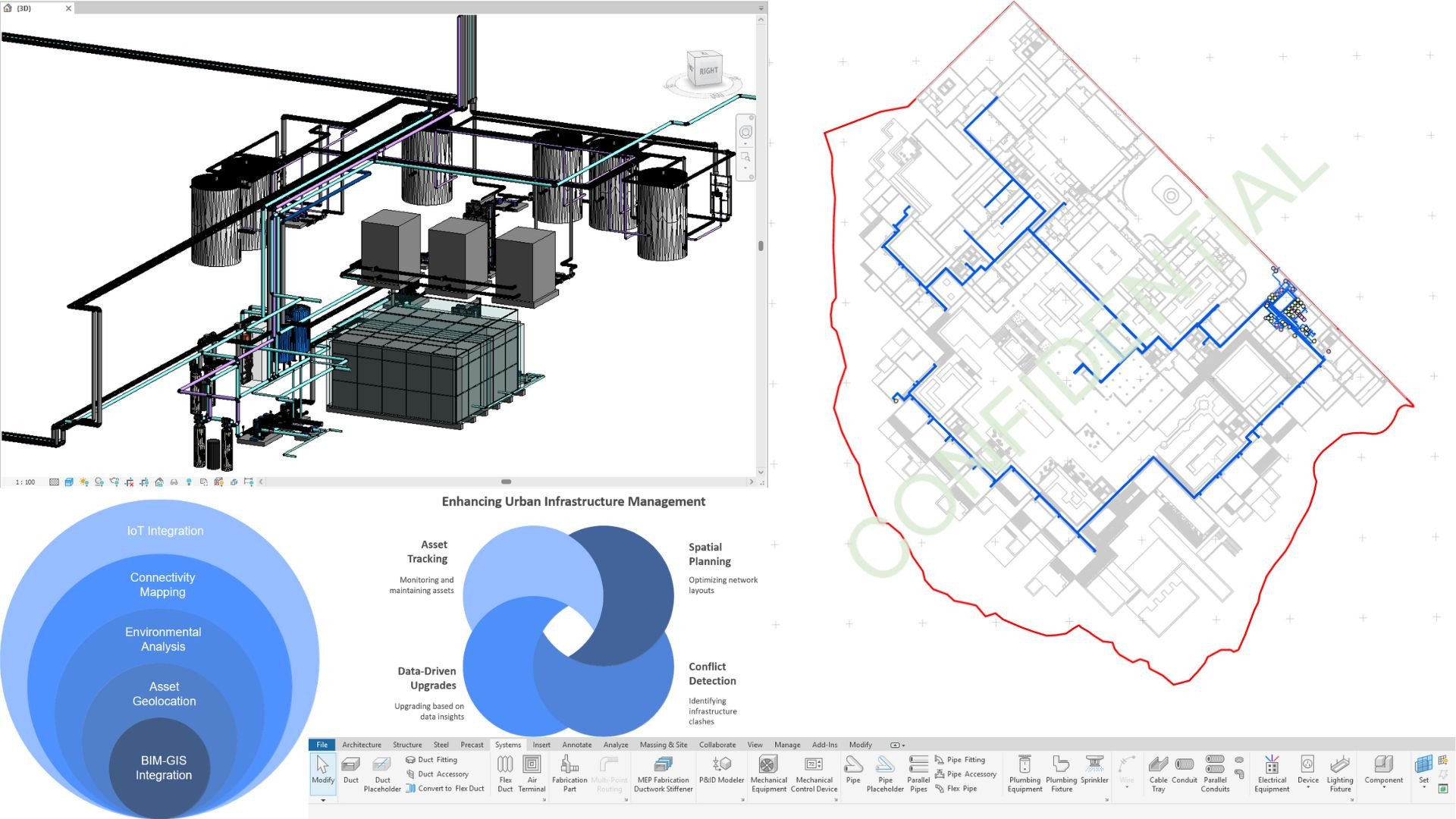
Introduction Utility networks are the hidden lifelines of modern cities — from water pipelines to electrical grids. Yet, planning, managing, and upgrading these networks remains a challenge, especially when they span vast and varied urban geographies. This is where the fusion of Revit’s detailed BIM modeling and GIS’s spatial intelligence proves invaluable. In this blog, we explore how Revit mode…
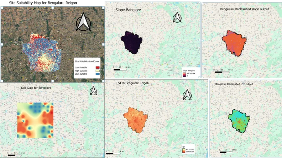
Introduction Suitability analysis is a vital component of spatial planning, allowing decision-makers to identify the most appropriate locations for specific land uses based on multiple criteria. In a world facing rapid urbanization, food insecurity, and climate change, the demand for smart land use decisions has never been greater. Whether it's identifying the best site for agriculture, infrastru…
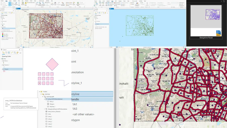
Introduction The convergence of CAD (Computer-Aided Design) and GIS (Geographic Information Systems) has unlocked new possibilities for professionals working in urban planning, civil engineering, environmental management, and infrastructure development. AutoCAD is a widely used tool for designing and drafting, while ArcGIS Pro provides powerful spatial analysis and mapping capabilities. Integrati…
civil-engineeringengineering
research.io
Sign up to keep scrolling
Create your feed subscriptions, save articles, keep scrolling.