


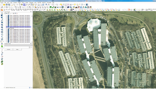
High R esolution Vertical Aerial photography for England has been released as Open Data from the Environment Agency. High Resolutions range from 50cm to 10cm (Orthorectified) Downloaded SU46NE.zip (Newbury) Image showing Vodafone HQ at 20cm Resolution "Vertical aerial photography is an airborne mapping technique, which measures reflected light in the red, green, blue and near infra-red spectrum. Images of the ground are captured at resolutions between 10cm and 50cm, and ortho-rectified using simultaneous LIDAR and GPS to a high spatial accuracy. The Environment Agency has been capturing vertical aerial photography data regularly since 2006. As of May 2016 we have 750 discrete individual surveys covering approximately 29,000km2, each ranging in coverage from a few square kilometres to hundreds of square kilometres. Historic data are available for some areas where we have carried out repeat surveys. Photography can be captured in all survey conditions, including incident response where it is used to derive flood outlines. The photography is supplied as a raster dataset in ECW (enhanced compressed wavelet) format as either a true colour (RGB), near infra-red (NIR) or a 4-band (RGBN) dataset. The data are presented as tiles in British National Grid OSGB 1936 projections. Attribution statement: © Environment Agency copyright and/or database right 2016. All rights reserved." Note all Aerial Imagery is in British National Grid (OSGB36) and in ECW format. QGIS will open this without plugins (on Windows only) Mac and Linux GIS users need to do more workarounds . To download your area of Interest. http://environment.data.gov.uk/ds/survey/index.jsp#/survey (click on the map and scroll to the bottom of the list past lidar to find the links and file sizes) Mapperz Mapping News Blog
Vertical Aerial Photography Environment Agency Released [Open Data]
noreply@blogger.com (Mapperz)