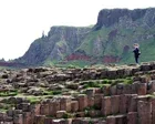
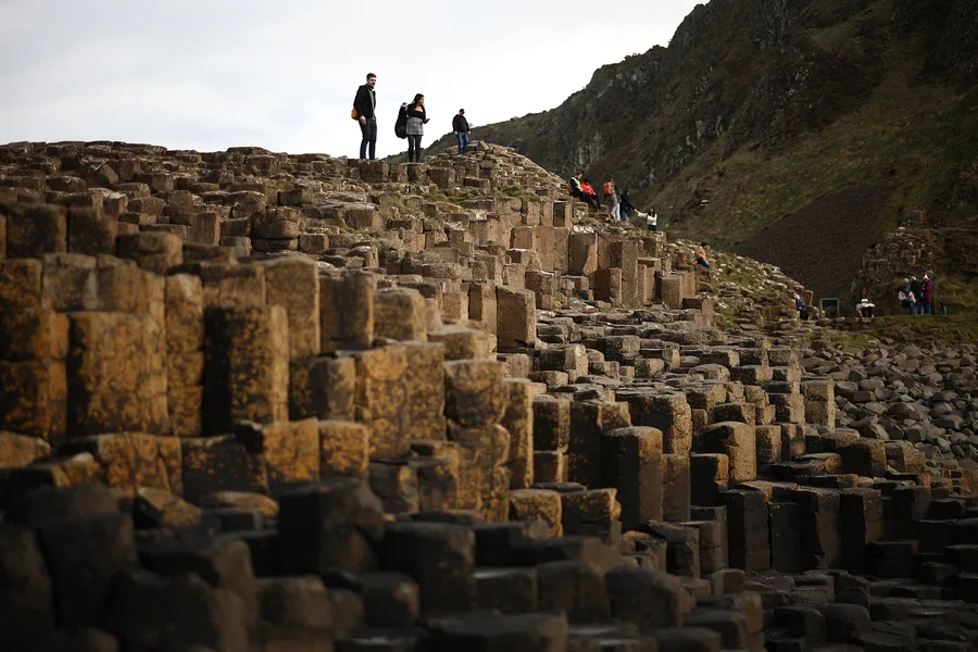
The history of an iconic UK landmark could be turned on its head, researchers have revealed. Scientists have uncovered fresh insights into how the Giant's Causeway came to exist. Research from the British Geological Survey shows Northern Ireland's volcanic history unfolded far more rapidly than experts previously believed. The volcanic activity that produced the Causeway's famous columns took pla…
Geochronologists say Antrim coastline’s basalt columns developed over 5.5m years – 8m less than thought For centuries, the tale has been passed from generation to generation: how the Irish giant Finn McCool built the Giant’s Causeway in Northern Ireland to fight Benandonner, his Scottish rival, by hurling chunks of the Antrim coastline into the sea. Now, scientists have revealed it was intense vo…
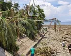
‘Coastal uplift’ exposes coral and kills marine life, as residents say shorelines extended by up to 200 metres A powerful earthquake that killed at least 61 people in the Philippines this week raised the seabed by as much as 2 metres (6.6 feet), exposing coral and harming marine life, the environment department said on Sunday. At least 40 people are still missing after the 7.8-magnitude tremor in…
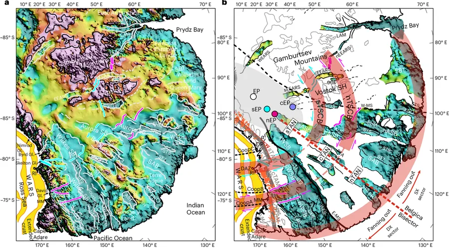
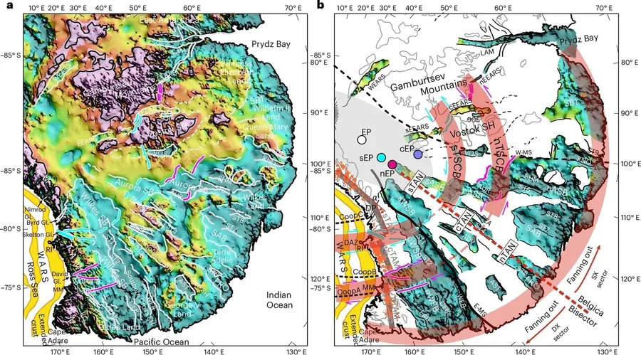
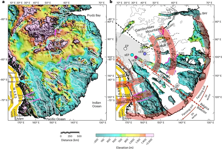
An international team of researchers including our Department of Geography has discovered a vast geological structure hidden beneath the East Antarctic Ice Sheet. The findings are published in the journal Nature Geoscience. The structure is made up of a system of enormous subglacial basins buried in ice over three kilometers thick in parts. Together, the […]
A huge earthquake fault line has been found underneath Auckland, New Zealand's largest city. The fault line, just south of the city, is active and could cause a city-destroying earthquake, new research shows. The discovery has also raised questions over a recent decision to exempt Auckland from earthquake building regulations. A study in the New Zealand Journal of Geology and Geophysics shows tha…
earth-sciencegeologyseismology
Google News Content : ScienceAlert : The Best in Science News and Amazing Breakthroughs
The city is exempted from earthquake building rules due to its northerly location, but a study of the Mangatangi Fault has thrown that into question A fault line south of New Zealand’s most populated city, Auckland, is active and could trigger a devastating earthquake new research shows, dispelling the region’s long-held belief it was largely immune from intense seismic activity. The research has…
Earth was bombarded by impactors in its first couple billion years. These impacts created a vast network of hydrothermal systems in the crust that could've spawned life. New research examines their extent.
Corona Heights fault, California. (a) Whole outcrop view. The inset corresponds to the surface shown on (c). (b) Zoom on the fault showing different segments constituting the surface. (c, d) Map of fault surfaces scanned using LiDAR. The inset in (c) corresponds to the patch shown on (d). Credit: Candela et al. [2011] , Figure 2(a-d)
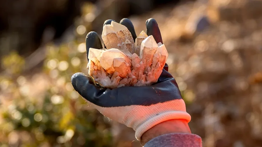
Equipped with rock picks and hand lenses, a team of geoscientists deployed to the Mojave Desert recently to investigate a tantalizing “fingerprint” detected by a NASA sensor. Their target: a cache of topaz hiding in plain sight. The geologists weren’t searching for gem-grade treasure. Rather, the presence of topaz could hint at a more valuable […] The post NASA, USGS Scientists Go Rock Hounding i…
The asteroid impact that wiped out the dinosaurs 66 million years ago is often remembered as one of the most destructive events in Earth’s history. However, new research suggests that the same catastrophe may also have created an underground environment where life could thrive for millions of years. An international team of scientists has found […] The post Dinosaur-killing asteroid may have crea…
Scientists have discovered a colossal hidden structure beneath Antarctica that could reshape our understanding of the continent’s past and present. Scientists have identified a massive hidden geological formation beneath East Antarctica, revealing a continent-scale structure buried under some of the thickest ice on Earth. The discovery was made by an international team of researchers that [...]
Companies are drilling exploratory wells to look for geologic hydrogen thousands of feet below Iowa's surface. This photo shows a well near Vincent, just northeast of Fort Dodge, in September 2024. Photo provided by Ryan Clark, Iowa Geological Survey.
AMES, Iowa – The geologists spoke in apocalyptic terms about Iowa’s distant past:
“A rift developed deep in the Earth, magma came up and tried to s…
A new Memorandum of Understanding reaffirms the UK’s support of Ukraine’s ambitions to develop its critical mineral resources, paving the way for collaboration through capacity-building programmes. The post Ukraine and the UK strengthen their commitment to geological cooperation appeared first on British Geological Survey .
earth-sciencegeology
Frontiers in Earth Science | New and Recent Articles
The Penggongmiao complex pluton, located in the Nanling metallogenic belt of South China, provides a critical record of Early Paleozoic (Caledonian) magmatism, but the genesis and mineralization potential of the biotite monzogranite of the pluton have not been constrained. This study presents new whole-rock geochemistry, zircon U–Pb ages, and Sr–Nd–Hf isotopic data for the Penggongmiao biotite mo…
A mysterious geological structure that resembles a human hand with outstretched fingers has been revealed beneath East Antarctica. The discovery shows the frozen continent still hides many geological secrets.
earth-sciencegeology
research.io
Sign up to keep scrolling
Create your feed subscriptions, save articles, keep scrolling.