


Three weeks ago I started building a map that argues back. Today it is public. 🗺️ argos-geo.org/map What you can do: Click any building, road, beach, or POI See travel time to the fire station and nearest ferry port Toggle wildfire risk and flash-flood layers Find the lighthouse nobody asked about (102 minutes, boat-only) The stack: PostGIS + FastAPI + MapLibre GL + PMTiles. Hosted on GitHub Pages. Costs €0/month. The data: OpenStreetMap, Copernicus DEM, Sentinel-2, NASA FIRMS, EFFIS. All open. All attributed. This is a static snapshot. Phase 2 adds real-time feeds. Phase 3 adds a municipality pilot. I wrote about how it happened: I built a digital twin of a Greek island and it found a lighthouse no one asked about Panagis Tzivras Panagis Tzivras Panagis Tzivras Follow Aug 18 I built a digital twin of a Greek island and it found a lighthouse no one asked about # opensource # geospatial # postgressql # digitaltwin Add Comment 5 min read Coming next: Build Log #2. Why the model thinks Greek firs burn like pine (and why it is wrong). Built in Kefalonia. Watching over the places we call home.
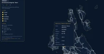
ARGOS v0.0.1 is live: a digital twin of Kefalonia
Panagis Tzivras